
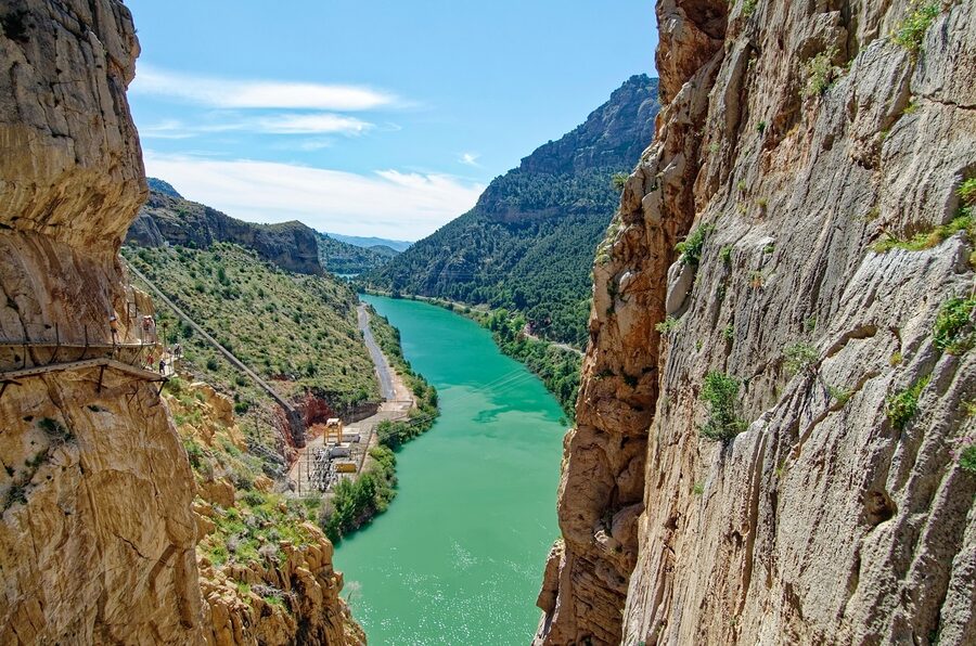
You round the last bend in the gorge and the wood beneath your boots stops being a path. It becomes a thin shelf bolted to a wall of grey limestone with a hundred metres of empty air below it. The wind in the Desfiladero de los Gaitanes is dry and steady, the Guadalhorce River is a small green ribbon at the bottom, and the only sound is your own footsteps on the boards. This is the moment the Caminito del Rey earns its old nickname, even though the new boardwalk is now safer than most pavements you walk on at home.
Below your feet is the original 1905 path, crumbled in places, just one metre lower than the new one. They left it there on purpose. You glance down, take a step, glance down again. Your stomach does something. You keep walking.
In a hurry: three good ways to do the Caminito
Quick picks
- From Málaga, transport included ($69): the simplest version. Coach pickup, entry, helmet, guide, return. Book the Málaga full-day tour on GetYourGuide.
- You arrange transport, just need entry + guide ($35): the value pick if you’re already near El Chorro or driving in from Ronda or Antequera. Book the entry + guide ticket.
- Andalusia-region pickup with guide ($34): a slightly different operator with the same format, useful if the first two slots are sold out for your dates. Book the Andalusia entry + guide.
None of the three is a bad pick. The differences are about how you get there, not what you see on the path. Below I break down which one fits which kind of trip.
What the Caminito actually is
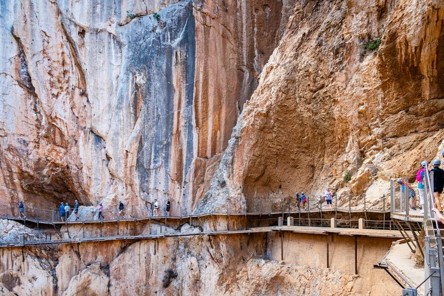
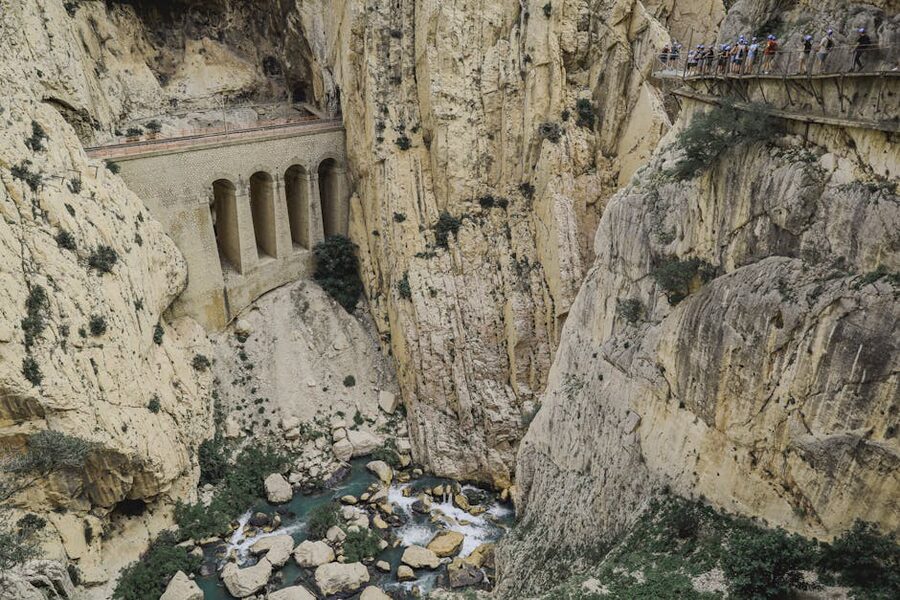
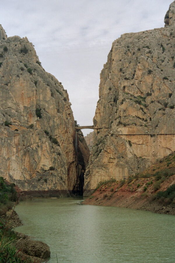
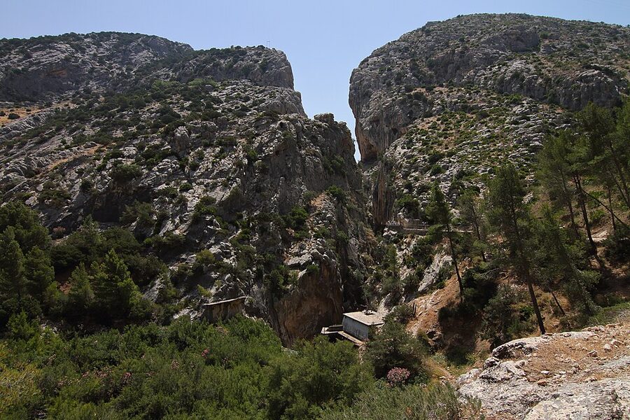
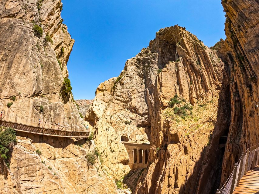
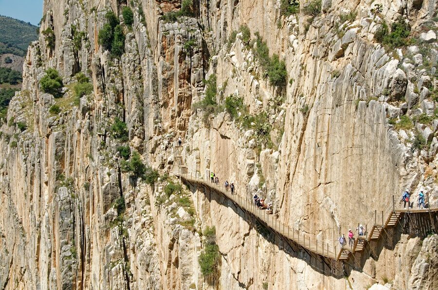
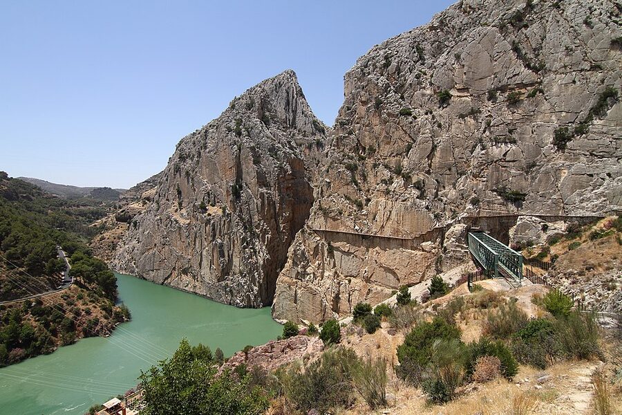
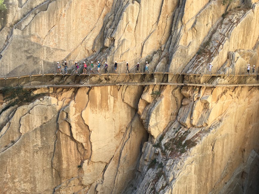
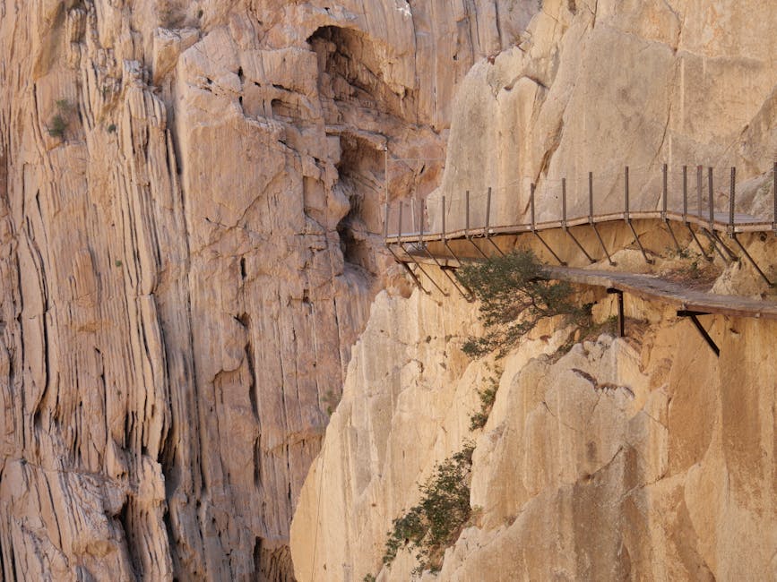
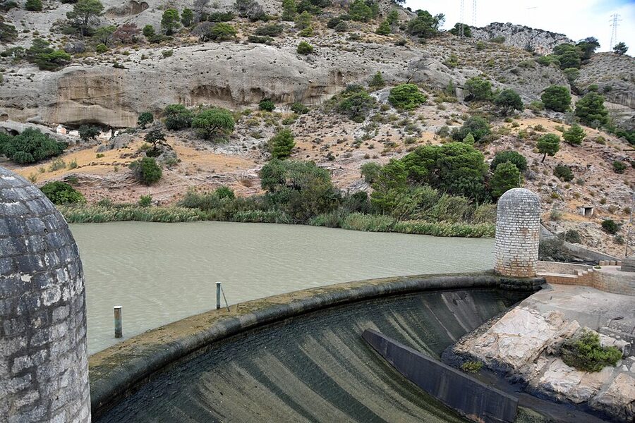
The Caminito del Rey is a 7.7 kilometre walk through one of the most dramatic gorges in southern Europe. The boardwalks make up about three kilometres of the route, pinned to the limestone walls of the Desfiladero de los Gaitanes, the gorge that the Guadalhorce River carved between Ardales and the village of El Chorro. It sits roughly an hour north of Málaga. For most of the dramatic stretch you are about a hundred metres above the river, with the cliffs continuing roughly twice that distance straight up above you.
The walk is one-way, north to south. You enter at the northern gate near the Restaurante El Kiosko (after a 1.5km approach through a tunnel and along a path), you walk through the gorge for around two hours, and you finish at the village of El Chorro on the south side. From there you take a shuttle bus back to your starting car park or, if you came on a guided tour, the coach picks you up and drives you back.
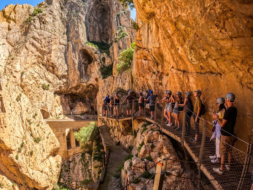
The path is wider than people expect. It’s a metre wide, with a sturdy steel railing along the cliff side. Children under eight are not allowed on. Children eight and up are fine if they’re comfortable with heights. Most fit adults walk it without trouble. If you have a serious vertigo problem, the third section is going to test you.
Why “the most dangerous path in Europe” got rebuilt
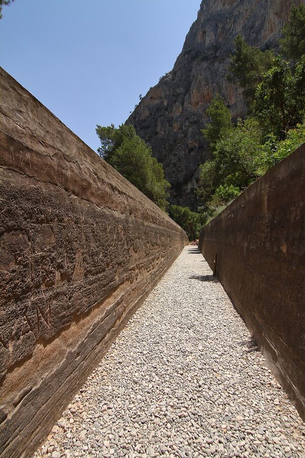
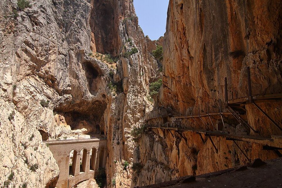
The story of the Caminito starts in 1901, with a hydroelectric problem. Two power stations had been built at Chorro Falls and Gaitanejo Falls, and engineers needed a service path through the gorge to move men and materials between the dam, the canal and the turbines. They cut a one-metre-wide concrete walkway directly into the limestone wall. It took four years (1901 to 1905) to finish.
King Alfonso XIII walked the path in 1921, on his way to inaugurate a new dam. The press called it the camino del rey, the king’s path, and the diminutive caminito stuck.
For the next eighty years the path served the dam workers. Then, in the 1990s, the Sevillana hydroelectric company stopped maintaining it. The concrete crumbled. Whole sections of railing fell into the river. Holes opened up in the floor. None of this stopped adventurers from climbing onto it. Five people died on the path between 1999 and 2000, and in 2001 the regional government finally closed it.
Spanish papers started calling it el camino más peligroso del mundo, the most dangerous path in the world. YouTube videos of climbers hopping the gaps in the floor went viral. The path’s terrible reputation is, ironically, what funded its rebuild.
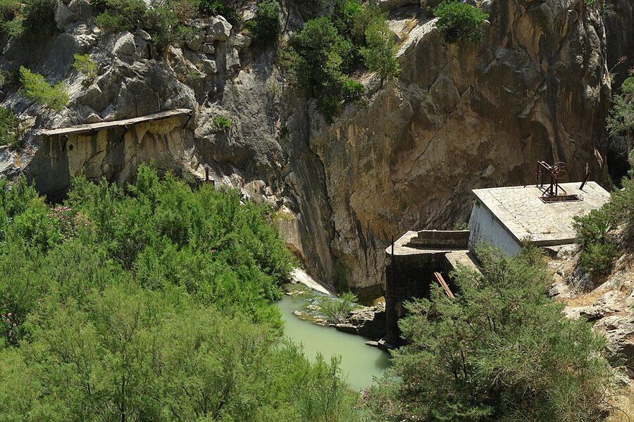
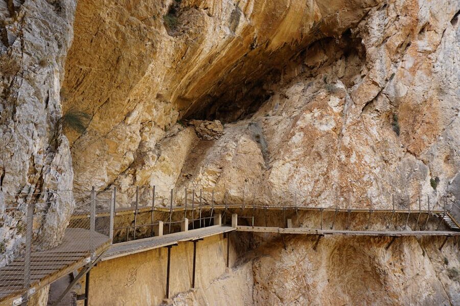
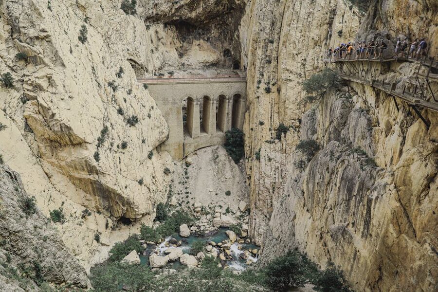
The Junta de Andalucía and the provincial government of Málaga rebuilt it between 2014 and 2015. The new path is a wooden boardwalk on steel anchors drilled into the rock. They left the original 1905 walkway in place, exposed, just below the new one. You walk for a kilometre with a half-broken concrete edge visible a metre under your feet. It’s the single most effective museum exhibit I’ve seen on any walk in Spain. You don’t need a sign explaining how dangerous this used to be. You can see it.
The booking nightmare, and the workaround
Caminito del Rey tickets are timed-entry. The official website releases them up to three months in advance and during peak weeks (April through October, especially weekends) they sell out within an hour of release. You have two ticket types on the official site: General (entry only, around €10) and Tour (entry plus a guide, around €18). General tickets sell out first because they’re cheaper and let you walk at your own pace.
The cheapest official tickets cap at 50 people every half hour to keep the path uncrowded. That’s a hard cap. There is no oversell.
If you missed the three-month-out window, the practical workaround is a guided tour through GetYourGuide or Viator. Tour operators buy blocks of tickets in advance for their guided slots, so they often have availability when the official site says “sold out”. The tradeoff is you pay a bit more (around €35 to €69 depending on whether transport is included) and you walk in a small group with a guide.
Is the guided tour worth it? My take: the guide does add real context for the engineering and the history, especially around the dams and the older walkway. But the path itself is so visually overwhelming you spend most of it staring up or down rather than listening. If you’re confident you can read up beforehand and don’t mind the small extra cost, book the guided tour purely for the entry guarantee.
The three best tours to book
I’ve ranked these by the kind of trip you’re on rather than by price. Pick the one that matches how you’re getting there.
1. Málaga: Caminito Del Rey Guided Tour With Transportation: $69
This is the right pick if you’re staying in Málaga and don’t want to deal with the Renfe schedules or the Álora-to-Ardales bus connection. Our review of the Málaga full-day tour covers what’s actually included (helmet, hairnet, guide, return transport, entry) and what you still need to bring (water, sun cream, walking shoes, ideally a light jacket because the gorge is windy even in August). It’s the most-booked Caminito tour for a reason: the logistics are sorted, you’re picked up and dropped off, and the price is fair.
2. Caminito Del Rey Guided Tour and Entry Ticket: $35
This is the best pick if you’re already in El Chorro or Ardales, or if you’ve rented a car and you’re driving in from Ronda or Antequera. Our review of this entry plus guide ticket goes into the meeting point logistics and what to do with your car (there’s a free car park near the southern exit, and the operators run a return shuttle). At half the price of the Málaga full-day, it’s the value pick when you don’t need transport.
3. Caminito Del Rey Entry Ticket and Guided Tour: $34
A near-twin of option 2 from a different operator, listed under Andalusia rather than El Chorro. Our review of this Andalusia-region tour notes the format is the same: meet at the north gate, two-hour guided walk, return shuttle. Worth checking when the other two slots are sold out for your travel dates.
Getting to the start: drive, train, or organised tour
The Caminito has two entrances, north and south, and you walk one-way from north to south. That makes the logistics more complicated than they look on a map. Here’s how the three realistic options compare.
Option 1: organised tour from Málaga
Easiest by a wide margin. The coach picks you up in central Málaga, drops you at the north gate, picks you up at the south exit, drives you back. You don’t think about transfers, parking, or buses. This is what I’d do as a first-timer. It’s also what most visitors do, which is why the Málaga full-day option is the most-booked Caminito tour every year.
Option 2: drive yourself
Around 50 minutes from Málaga or about 75 minutes from Ronda. There’s a free car park near the southern exit at the village of El Chorro. From there, you take the operator-run shuttle bus (around €1.55 each way) up to the northern entrance, walk the path one way, and your car is waiting at the end.
This is the cheapest option if you’re already renting a car for the rest of your Andalusia trip. It also leaves you free to add a side trip to El Torcal de Antequera or the white village of Ardales on the same day. Don’t try to drive to the north entrance and walk back. That’s an out-and-back, which the path doesn’t allow, and you’d be stuck.
Option 3: train and bus combo
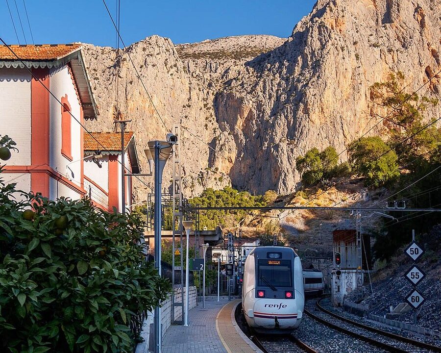
Possible but fiddly. The Renfe Cercanías line C-2 runs from Málaga María Zambrano to El Chorro-Caminito del Rey station. Trains are infrequent (often only two or three a day at usable times), and they drop you at the southern exit, which is the wrong end. From there you’d take the shuttle bus up to the northern entrance.
The other public transport route is bus 231 from Málaga to Álora (about an hour), then bus 340 from Álora to Ardales (about thirty minutes). The schedules don’t talk to each other. I tried this route once and it ate four hours. Skip it. If you can’t drive and you don’t want a tour, take the train and accept that it’s a long day.
What the walk is actually like
You break the route into three sections. They feel completely different from each other.
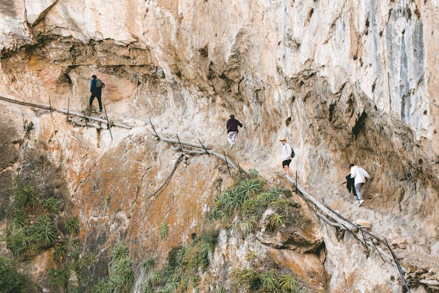
Section 1: into the gorge
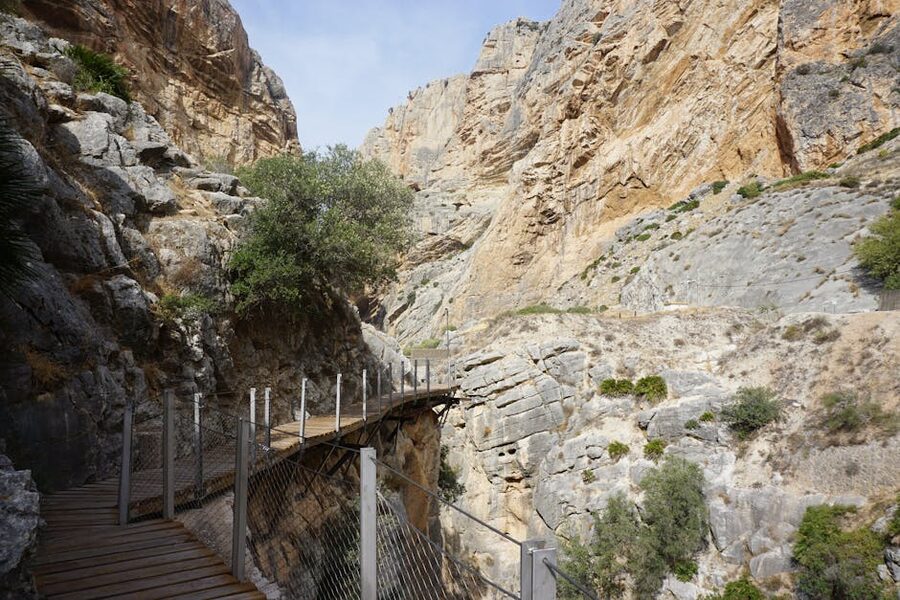
You start through a wooden gate above the dam, climb a flight of stairs onto the boardwalk, and the gorge swallows you. The first stretch is narrow and windy, with the cliff on your left and the drop on your right. The river is shallow and grey-green below, and the rock walls feel close enough to touch. Most of this section is in shadow even on a hot day. Wear a thin layer.
The first half-hour is when most people figure out their relationship with heights. There’s a bench cut into a small alcove around the 30-minute mark. Use it. Drink water. The path is one-way, so there’s no rush.
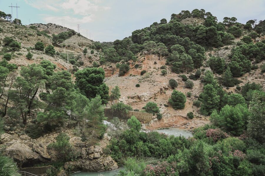
Section 2: the open valley
You exit the first gorge into the Valle del Hoyo, an open valley with pine trees and a wider river. This is the ten-minute breather of the walk. There’s no exposure here, the path is wide, and the railway line that cuts through the cliffs across the river comes into view for the first time. You can see old stone water viaducts that piped river water through the gorge walls a hundred years ago. It’s the section I’d take photos in if I had to pick one. The drama is back-loaded.
Section 3: the dramatic gorge and the suspension bridge
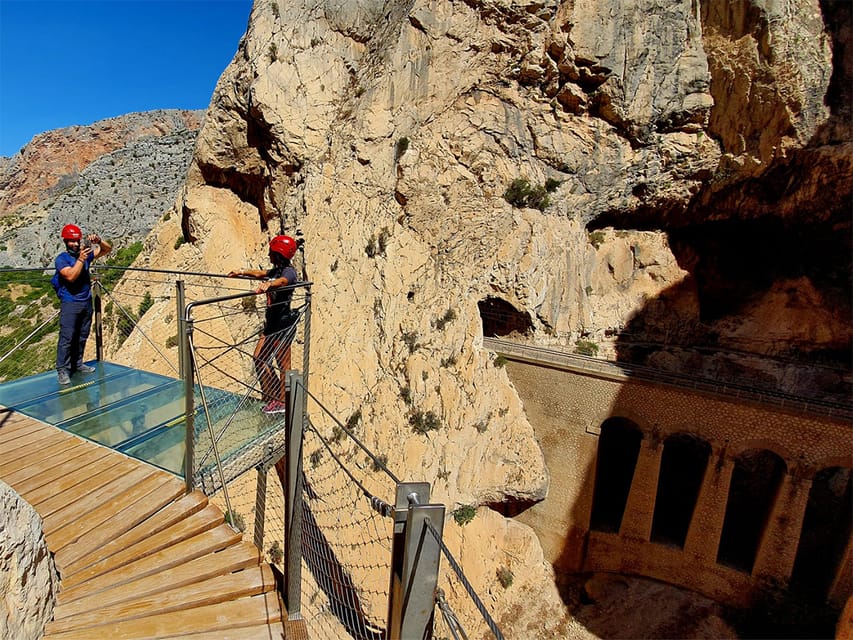
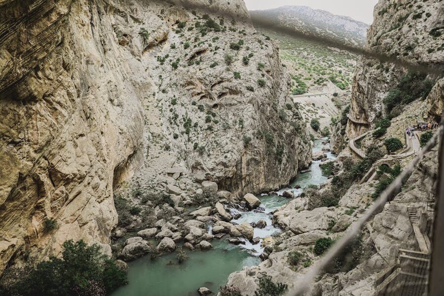
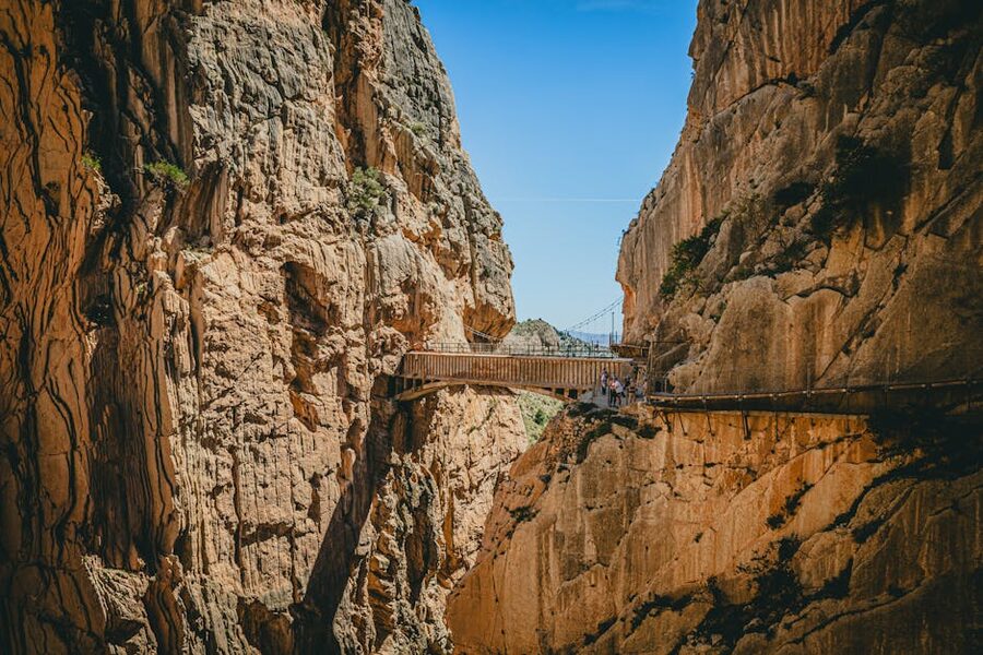
Then the rock closes in again. The cliffs go vertical on both sides, the gorge narrows, and the boardwalk pins itself to the wall 100 metres above the river. The exposed concrete of the original 1905 path is visible right below your feet, broken in places, with the river through the gaps. There’s a glass balcony where you can stand and look straight down. I lasted about ten seconds on it.
Around the corner is the suspension bridge. It’s one metre wide, it spans the narrowest point of the gorge, and you can see straight through the metal grate floor to the river 105 metres below. It sways slightly when more than a couple of people are on it. Most visitors stop in the middle for a photo. Most are quieter on the bridge than they were before it.
After the bridge the path turns sharp left, climbs a steep set of metal stairs out of the gorge, and you’re on a forested bluff with the canyon disappearing behind you. There’s a rest area, a viewpoint with bench seating, and a long downhill walk to the village of El Chorro.
The southern exit and El Chorro village
From the southern gate it’s about a 20-minute walk through pine forest, past a small chapel and a railway bridge, and into the village of El Chorro. You hand back your helmet at the kiosk near the train station. There are bathrooms and a couple of cafés. If you drove in, the shuttle bus runs from here back to the northern car park every 15 to 20 minutes.
The village itself is quiet. There’s a restaurant called El Kiosko at the northern entrance and a couple of options near the train station at the southern end. Both are fine. Neither is a destination meal. If you want something better, drive 20 minutes back into Ardales for whitewashed-village lunch on a real square.
What to wear, what to bring, what to leave behind
The Caminito is rated as easy hiking, and that’s accurate. You don’t need boots. Trainers with a grip sole are fine. The bigger questions are wind, sun, and water.
- Layers. The gorge is shaded and windy. Even in August it can be 8 to 10 degrees cooler inside the gorge than out in the valley. A light jacket or fleece is worth carrying.
- Water. There are no fountains on the path itself. Bring at least a litre per person. There’s a kiosk at the northern entrance to buy bottles before you start.
- Sun cream and a hat. Section 2 is open valley with no shade. The Andalusian sun in July and August is no joke.
- A small backpack. Anything bigger than a daypack is awkward on the boardwalks because the path is narrow.
- Helmet and hairnet. Provided free at the entrance. The hairnet goes under the helmet for hygiene. You hand both back at the south exit.
What to leave behind: large camera tripods (banned, the rangers will turn you back), drones (also banned, the gorge is a protected nature reserve), and any thought of bringing a dog. No pets allowed, full stop.
When to walk it: the best months and times of day
The Caminito is open year-round but closed every Monday for maintenance. If your Monday is in Andalusia, plan something else, like the white villages around Ronda or a day trip to Málaga’s Picasso museum (slug forthcoming, this is a forward link).
Best months are October to early December and March to early May. The temperatures are mild, the light is low and good for photos, and the crowds are smaller than the summer months. April is the best of the bunch, with wildflowers in the Valle del Hoyo and the river still running fast from winter rain, the same April-window logic that drives Keukenhof tulip planning.
Summer (June to September) is hot and the entrances are busy. The path itself doesn’t feel crowded thanks to the half-hourly entry caps, but the queues at the gate can be long. Aim for the first slot of the day (9:30am opening) or the last (around 2pm). Avoid the midday slots in July and August.
Winter (December to February) is the quietest. The path is sometimes closed for a day or two after heavy rain, especially in January, but most days run. The water in the river is at its highest, the light is dramatic, and you might have whole stretches of the boardwalk to yourself. Pack a real jacket. The wind through the gorge is biting.
Combining the Caminito with other Andalusia trips
The Caminito takes about half a day if you’re driving and a full day if you’re tourist-coached from Málaga. That leaves room to combine it with other things. Here are the three combinations I’ve actually done.
Caminito and Ronda. Drive from Ronda in the morning, walk the Caminito, drive back. About 75 minutes each way. Ronda’s own gorge bridge feels almost tame after the Caminito’s, but the town’s white-village mood is the right wind-down. The white villages around Ronda are an easy add-on, and we cover them in our forthcoming guide to ronda and the white villages from Seville.
Caminito and El Torcal de Antequera. El Torcal is a karst limestone landscape about 40 minutes east of the Caminito. Strange weathered rock formations, easy looped walks. If your legs are still up for another hour of hiking after the Caminito, this is a fantastic same-day combination.
Caminito and a Málaga overnight. Take the morning Málaga full-day tour, get back into the city by 4pm, spend the late afternoon at the Picasso Museum or the Alcazaba, and have dinner in the old town. Málaga’s compact enough that this works.
Where the Caminito sits in the wider Andalusia trip
If you’re putting together an Andalusia itinerary, the Caminito is the standout day-hike of the region. The big-city draws are different in feel: the Nasrid Palaces of the Alhambra in Granada, the Mosque-Cathedral of Córdoba, and the Royal Alcázar of Seville are all timed-entry historical monuments that need similar advance booking discipline. The Caminito is the natural one of the set, and after three days of Moorish architecture it lands hard. Pair it with a Sacromonte cave-flamenco evening if you’re swinging up to Granada, or end the day with a fino and a tapa back in Málaga.
If you’ve already walked Italian cliff trails like the Cinque Terre coastal paths, you’ll find the Caminito very different. The Cinque Terre is sea, vines, towns. The Caminito is rock, river, gorge, in the same family as the limestone cliffs above the Verdon Gorge in Provence. Both are beautiful, neither is a substitute for the other. Same for walking up Vesuvius, Etna’s craters, or the high ridges of Chamonix-Mont Blanc: those are volcano walks and Alpine snow walks, dust and lava and sulphur and ice. The Caminito is a wood-and-steel boardwalk above a river. The drama is engineered.
Closer to home in the same Andalusia batch, the Montserrat day trip from Barcelona is the closest equivalent in Spain: cliffside, dramatic, half-day-able. Barcelona’s Montjuïc cable car is the urban version of cliff-edge views. The Dutch parallel works in reverse: a flat-land day trip from a city like Zaanse Schans from Amsterdam is the same half-day rhythm in completely different terrain. None of these trips are doing the same thing. The Caminito is closer to a railway-engineering feat than to a hike.
One last cross-Spain link worth flagging: if you’re heading north after Andalusia, the Bernina Express from Milan and the Borromean Islands are similarly engineered cliff-and-water experiences in northern Italy. The Caminito sits in the same family of human-made paths through impossible terrain.
The questions people ask before they book
How long does the walk take?
About two hours from the northern entrance gate to the El Chorro village exit, plus 20 minutes from the car park to the entrance and 20 minutes from the exit gate to the village. Plan two and a half hours of walking, plus an hour for queues, photos, and bathroom stops. Most people are out three and a half to four hours from the moment they reach the entrance car park.
How fit do I need to be?
If you can walk five kilometres without stopping, you can do this. There are no steep climbs and no scrambling. The boardwalk is flat for most of the route. The one moderately tough bit is the metal staircase at the southern end, climbing out of the gorge.
Is it safe for kids?
Children under eight are not allowed. From eight up, it’s a question of temperament. The path itself is fully railed and as safe as any boardwalk gets. The gaps in the floor and the views down are what bother some kids (and some adults). If your child is sensitive to heights, this is not the place to find that out.
Can you walk it without a guide?
Yes, with a General ticket. There’s no need for a guide for navigation: the path is one-way and signposted. The reason most people end up on a guided tour is that General tickets are gone faster than Tour tickets. If you can book three months out, go General and walk at your own pace.
What about vertigo?
The first 20 minutes of section 1 will tell you. If you’re shaky there, the third section is going to be much worse. There’s a turnaround possible at the start of section 1 if you genuinely can’t continue, but you have to walk back the way you came. Once you’re past the first gorge into Valle del Hoyo, there’s no turning back: you finish the walk forward to El Chorro.
What’s the deal with the helmet?
The Caminito is in active limestone country and small rockfalls happen, particularly after rain. The helmet protects against pebble-sized falls. Wearing it is mandatory, the rangers check at the entrance, and it’s free. The hairnet underneath is for hygiene because the helmets are reused. Put it on, don’t think about it.
One more thing: the original walkers
Before you reach the suspension bridge, there’s a small set of plaques set into the cliff. They commemorate climbers who died on the gorge before the path was rebuilt. Mostly Spanish, a few foreign, all between the late 1990s and the early 2000s. It’s a quiet moment on what is otherwise a triumphant walk. Worth pausing for. The reason this place is now safe is that other people walked it when it wasn’t.
If the Caminito hooks you
If a half-day at the Caminito leaves you wanting more of the same, southern Spain has a rhythm of cliff-and-engineering walks that pairs well with it. The Montserrat funicular and ridge walk in Catalonia is the closest cousin. Barcelona’s Montjuïc cable car is the lazier urban version of getting up to a cliff edge. For the historical-rebuild story specifically, walking through the Sassi of Matera in southern Italy hits a similar nerve: a place that was officially abandoned and dangerous, then carefully rebuilt as a destination. Different geography, same arc.
And once you’ve done the walk, take the train back into Málaga and have a proper Andalusian dinner. Boquerones in vinegar, a small plate of jamón, a glass of Pedro Ximénez. The Caminito earns it.